
Distribution of Geophysical Hazards
|
|

Describe the location of earthquakes and volcanoes in the world.
Earthquakes
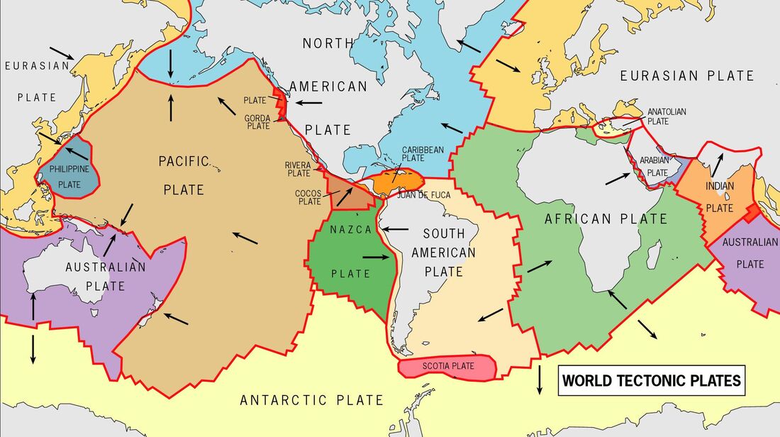
Earthquakes can strike any location at any time, but history shows they occur in the same general patterns year after year, principally in three large zones of the earth:
Volcanoes
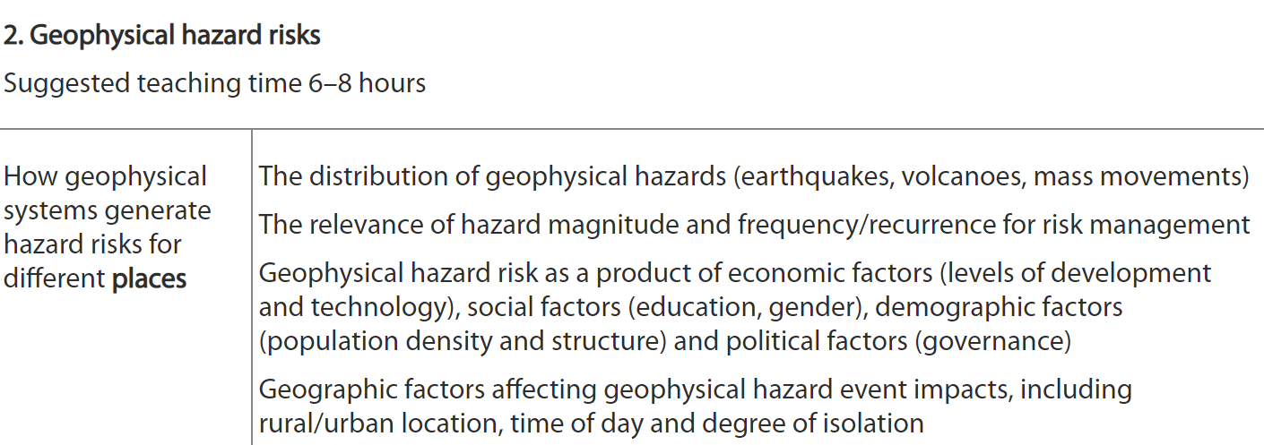
Volcanic eruptions occur only in certain places and do not occur randomly. That's because the Earth's outermost shell— the lithosphere—is broken into a series of slabs known as lithospheric or tectonic plates. These plates are rigid, but they float on the hotter, softer layer in the Earth's mantle. As the plates move about, they spread apart, collide, or slide past each other. Volcanoes occur most frequently at plate boundaries. Some volcanoes, like those that form the Hawaiian Islands, occur in the interior of plates at areas called hot spots. Although most of the active volcanoes we see on land occur where plates collide, the greatest number of the Earth's volcanoes are hidden from view, occurring on the ocean floor along spreading ridges. Mount St. Helens is typical of more than 80 percent of the volcanoes that have formed on land. Known as subduction zone volcanoes, they occur along the edges of continents where one plate dives, or subducts, beneath a second plate. When the subducting plate reaches about 100 kilometers (60 miles) into the Earth's hot mantle, it triggers partial melting of the overlying plate and forms new magma. Some of the magma rises and erupts as volcanoes.
Earthquakes can strike any location at any time, but history shows they occur in the same general patterns year after year, principally in three large zones of the earth:
- The world's greatest earthquake belt, the circum-Pacific seismic belt, is found along the rim of the Pacific Ocean, where about 81 percent of our planet's largest earthquakes occur. It has earned the nickname "Ring of Fire". Why do so many earthquakes originate in this region? The belt exists along boundaries of tectonic plates, where plates of mostly oceanic crust are sinking (or subducting) beneath another plate. Earthquakes in these subduction zones are caused by slip between plates and rupture within plates. Earthquakes in the curcum-Pacific seismic belt include the M9.5 Bio-Bio earthquake in Chile (1960) and the M9.2 Great Alaska Earthquake (1964).
- The Alpide earthquake belt extends from Java to Sumatra through the Himalayas, the Mediterranean, and out into the Atlantic. This belt accounts for about 17 percent of the world's largest earthquakes, including some of the most destructive, such as the 2005 M7.6 shock in Pakistan that killed over 80,000 and the 2004 M9.1 Indonesia earthquake, which generated a tsunami that killed over 230,000 people.
- The third prominent belt follows the submerged mid-Atlantic Ridge. The ridge marks where two tectonic plates are spreading apart (a divergent plate boundary). Most of the mid-Atlantic Ridge is deep underwater and far from human development, but Iceland, which sits directly over the mid-Atlantic Ridge, has experienced earthquakes as large as at least M6.9.
Volcanoes
Volcanic eruptions occur only in certain places and do not occur randomly. That's because the Earth's outermost shell— the lithosphere—is broken into a series of slabs known as lithospheric or tectonic plates. These plates are rigid, but they float on the hotter, softer layer in the Earth's mantle. As the plates move about, they spread apart, collide, or slide past each other. Volcanoes occur most frequently at plate boundaries. Some volcanoes, like those that form the Hawaiian Islands, occur in the interior of plates at areas called hot spots. Although most of the active volcanoes we see on land occur where plates collide, the greatest number of the Earth's volcanoes are hidden from view, occurring on the ocean floor along spreading ridges. Mount St. Helens is typical of more than 80 percent of the volcanoes that have formed on land. Known as subduction zone volcanoes, they occur along the edges of continents where one plate dives, or subducts, beneath a second plate. When the subducting plate reaches about 100 kilometers (60 miles) into the Earth's hot mantle, it triggers partial melting of the overlying plate and forms new magma. Some of the magma rises and erupts as volcanoes.
|
|
|
Mass Movements
A landslide is a mass movement of material, such as rock, earth or debris, down the slope of a hill or cliff. They can happen suddenly or move slowly over long periods of time. Landslides are classified by their type of movement. The four main types of movement are:Landslides can be classified as just one of these movements or, more commonly, can be a mixture of several.
Like sand sliding off a tipper truck, slopes eventually fail because they become too steep to hold onto their load. A landslide may occur because the strength of the material is weakened. This reduces the power of the 'glue' that cements the rock or soil grains together. Located on a slope, the rock is then no longer strong enough to resist the forces of gravity acting upon it.
Mass movement risk map
Several factors can increase a slopes susceptibility to a landslide event:
- water (rainfall or the movement of the sea) — this acts as a grease to the material increasing the likelihood that it will slip and also adds extra weight to the rock
- erosion processes — such as coastal erosion and river erosion
- steepness of slope
- type of 'rocks' — soft rock such as mudstone or hard rock such as limestone
- shape of the rock 'grains'
- jointing and orientation of bedding planes
- arrangement of the rock layers
- weathering processes — for example freeze-thaw reduces the stickiness (cohesion) between the rock grains.
- lack of vegetation which would help bind material together
- flooding
- volcanoes and earthquake activity nearby
- man's activity — mining, traffic vibrations or urbanisation which changes surface water drainage patterns
Vulnerability and Risk
What is Vulnerability
Vulnerability describes the characteristics and circumstances of a community, system or asset that make it susceptible to the damaging effects of a hazard. There are many aspects of vulnerability, arising from various physical, social, economic, and environmental factors. Examples may include:
The above explanation was taken from the United Nations (UN) International Strategy for Disaster Reduction (ISDR) Terminology on Disaster Risk Reduction. Follow the link to look up other terminologies.
There are four (4) main types of vulnerability:
1. Physical Vulnerability may be determined by aspects such as population density levels, remoteness of a settlement, the site, design and materials used for critical infrastructure and for housing (UNISDR).
Example: Wooden homes are less likely to collapse in an earthquake, but are more vulnerable to fire.
2. Social Vulnerability refers to the inability of people, organizations and societies to withstand adverse impacts to hazards due to characteristics inherent in social interactions, institutions and systems of cultural values. It is linked to the level of well being of individuals, communities and society. It includes aspects related to levels of literacy and education, the existence of peace and security, access to basic human rights, systems of good governance, social equity, positive traditional values, customs and ideological beliefs and overall collective organizational systems (UNISDR).
Example: When flooding occurs some citizens, such as children, elderly and differently-able, may be unable to protect themselves or evacuate if necessary.
3. Economic Vulnerability. The level of vulnerability is highly dependent upon the economic status of individuals, communities and nations The poor are usually more vulnerable to disasters because they lack the resources to build sturdy structures and put other engineering measures in place to protect themselves from being negatively impacted by disasters.
Example: Poorer families may live in squatter settlements because they cannot afford to live in safer (more expensive) areas.
4. Environmental Vulnerability. Natural resource depletion and resource degradation are key aspects of environmental vulnerability.
Example: Wetlands, such as the Caroni Swamp, are sensitive to increasing salinity from sea water, and pollution from stormwater runoff containing agricultural chemicals, eroded soils, etc.
What is Risk
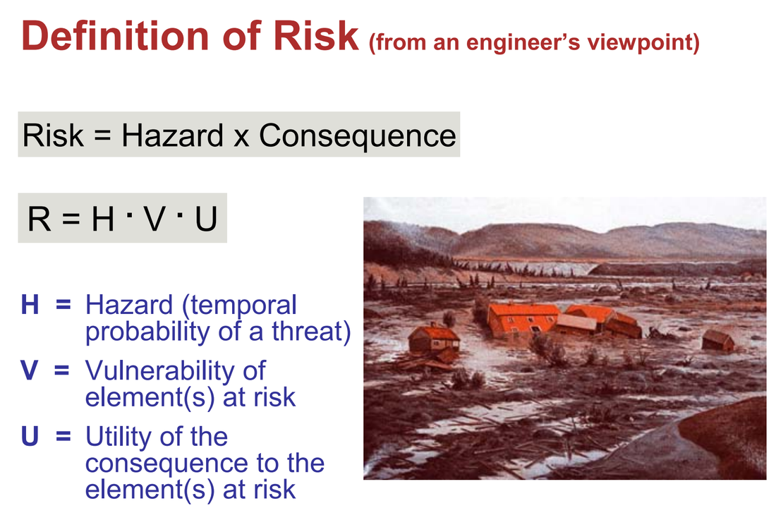
Risk (or more specifically, disaster risk) is the potential disaster losses (in terms of lives, health status, livelihoods, assets and services) which could occur to a particular community or a society over some specified future time period. (Reference UNISDR Terminology)
It considers the probability of harmful consequences, or expected losses (deaths, injuries, property, livelihoods, economic activity disrupted or environmentally damaged) resulting from interactions between natural or human induced hazards and vulnerable conditions.
Risk can be calculated using the following equation: Risk = Probability of Hazard x Degree of Vulnerability.
There are different ways of dealing with risk, such as:
Risk Acceptance: an informed decision to accept the possible consequences and likelihood of a particular risk.
Risk Avoidance: an informed decision to avoid involvement in activities leading to risk realization.
Risk Reduction refers to the application of appropriate techniques to reduce the likelihood of risk occurrence and its consequences.
Risk Transfer involves shifting of the burden of risk to another party. One of the most common forms of risk transfer is Insurance.
Vulnerability describes the characteristics and circumstances of a community, system or asset that make it susceptible to the damaging effects of a hazard. There are many aspects of vulnerability, arising from various physical, social, economic, and environmental factors. Examples may include:
- poor design and construction of buildings,
- inadequate protection of assets,
- lack of public information and awareness,
- limited official recognition of risks and preparedness measures, and
- disregard for wise environmental management.
The above explanation was taken from the United Nations (UN) International Strategy for Disaster Reduction (ISDR) Terminology on Disaster Risk Reduction. Follow the link to look up other terminologies.
There are four (4) main types of vulnerability:
1. Physical Vulnerability may be determined by aspects such as population density levels, remoteness of a settlement, the site, design and materials used for critical infrastructure and for housing (UNISDR).
Example: Wooden homes are less likely to collapse in an earthquake, but are more vulnerable to fire.
2. Social Vulnerability refers to the inability of people, organizations and societies to withstand adverse impacts to hazards due to characteristics inherent in social interactions, institutions and systems of cultural values. It is linked to the level of well being of individuals, communities and society. It includes aspects related to levels of literacy and education, the existence of peace and security, access to basic human rights, systems of good governance, social equity, positive traditional values, customs and ideological beliefs and overall collective organizational systems (UNISDR).
Example: When flooding occurs some citizens, such as children, elderly and differently-able, may be unable to protect themselves or evacuate if necessary.
3. Economic Vulnerability. The level of vulnerability is highly dependent upon the economic status of individuals, communities and nations The poor are usually more vulnerable to disasters because they lack the resources to build sturdy structures and put other engineering measures in place to protect themselves from being negatively impacted by disasters.
Example: Poorer families may live in squatter settlements because they cannot afford to live in safer (more expensive) areas.
4. Environmental Vulnerability. Natural resource depletion and resource degradation are key aspects of environmental vulnerability.
Example: Wetlands, such as the Caroni Swamp, are sensitive to increasing salinity from sea water, and pollution from stormwater runoff containing agricultural chemicals, eroded soils, etc.
What is Risk
Risk (or more specifically, disaster risk) is the potential disaster losses (in terms of lives, health status, livelihoods, assets and services) which could occur to a particular community or a society over some specified future time period. (Reference UNISDR Terminology)
It considers the probability of harmful consequences, or expected losses (deaths, injuries, property, livelihoods, economic activity disrupted or environmentally damaged) resulting from interactions between natural or human induced hazards and vulnerable conditions.
Risk can be calculated using the following equation: Risk = Probability of Hazard x Degree of Vulnerability.
There are different ways of dealing with risk, such as:
Risk Acceptance: an informed decision to accept the possible consequences and likelihood of a particular risk.
Risk Avoidance: an informed decision to avoid involvement in activities leading to risk realization.
Risk Reduction refers to the application of appropriate techniques to reduce the likelihood of risk occurrence and its consequences.
Risk Transfer involves shifting of the burden of risk to another party. One of the most common forms of risk transfer is Insurance.
|
|

Extended Reading
| gf731_what_makes_people_vulnerable_to_natural_hazards.pdf |
| Living on a plate margin |
| Why do some tectonic hazards turn into major disasters? |
| Factors Affecting Vulnerability |
