Earthquakes
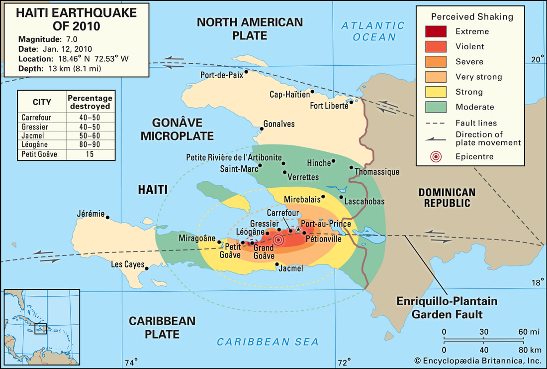
Haiti, 2010
|
Effects
Primary Destruction after the earthquake at Port-au-Prince, Haiti
Short-term
|
| ||||||
|
|
| ||||||||||||||||||
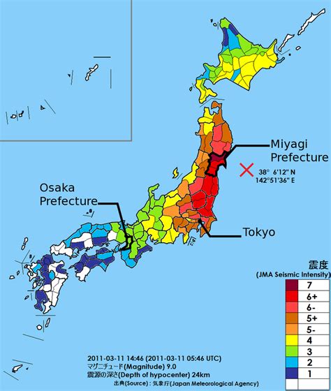
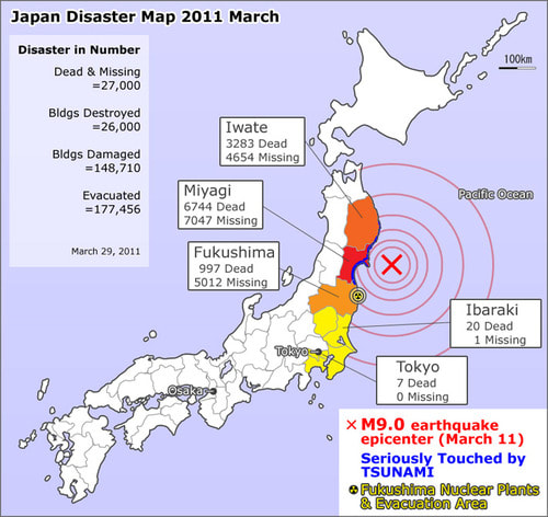
Japan, 2011
|
|
|
|
|
|
| ||||||||||||||||||
Volcanoes
anak krakatau, 2018 (LIC)
| |||||||
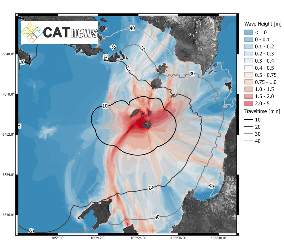
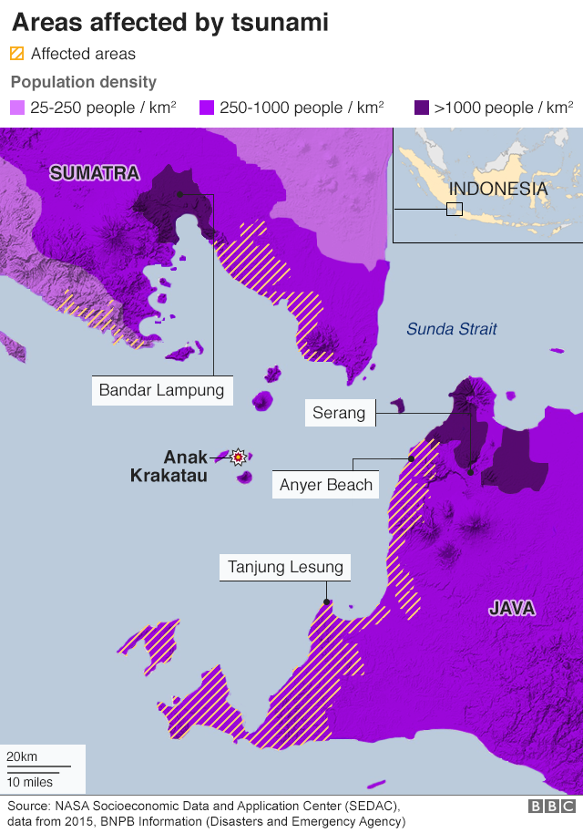
On Dec. 22 at 9:03 pm local time, a 64-hectare (158-acre) chunk of Anak Krakatau volcano, in Indonesia, slid into the ocean following an eruption. This landslide created a tsunami that struck coastal regions in Java and Sumatra, killing at least 426 people and injuring 7,202.
Satellite data and helicopter footage taken on Dec. 23 confirmed that part of the southwest sector of the volcano had collapsed into the sea. In a report on Dec. 29, Indonesia's Center of Volcanology and Geological Hazard Mitigation said that the height of Anak Krakatau went from 338 meters (1,108 feet) above sea level to 110 meters (360 feet).
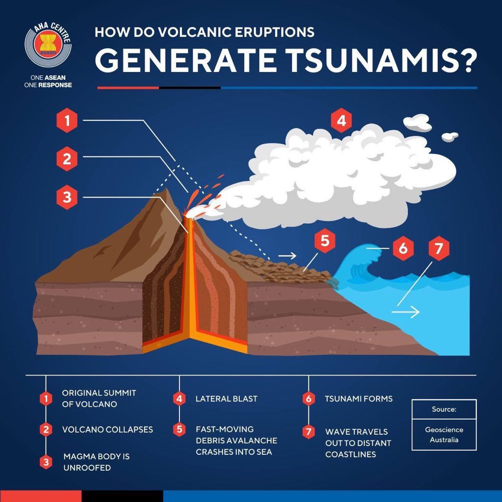
Although most tsunamis have a seismic origin (for example, the Sumatra, Indonesia one in 2004 and at Tohoku, Japan in 2011), they may also be triggered by phenomena related to large volcanic eruptions. Tsunamis caused by volcanoes can be triggered by submarine explosions or by large pyroclastic flows – a hot mix of volcanic gases, ash and blocks travelling at tens of miles per hour – if they enter in a body of water. Another cause is when a large crater forms due to the collapse of the roof of a magma chamber – a large reservoir of partially molten rock beneath the surface of the Earth – following an eruption. At Anak Krakatau, a large, rapidly sliding mass that struck the water led to the tsunami. These types of events are usually difficult to predict as most of the sliding mass is below water level.
These volcanic landslides can lead to major tsunamis. Landslide-triggered tsunamis similar to what happened at Anak Krakatau occurred in December 2002 when 17 millions cubic meters (600 millions cubic feet) of volcanic material from Stromboli volcano, in Italy, triggered a 8-meter-high wave.
More recently in June 2017, a 100-meter-high wave was triggered by a 45-million-cubic-meter (1.6-billion cubic-feet) landslide in Karrat Fjord, in Greenland, causing a sudden surge of seawater that wreaked havoc and killed four people in the fishing village of Nuugaatsiaq located about 20 km (12.5 miles) away from the collapse. These two tsunamis had few fatalities as they occurred either in relatively isolated locations (Karrat Fjord) or during a period of no tourist activity (Stromboli). This was obviously not the case at Anak Krakatau on Dec. 22.
|
|
|
|
Eyjafjallajökull, 2010 (HIC)
| Eyjafjallajökull, 2010 (worksheet) | |
| File Size: | 388 kb |
| File Type: | |
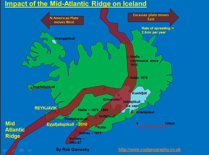
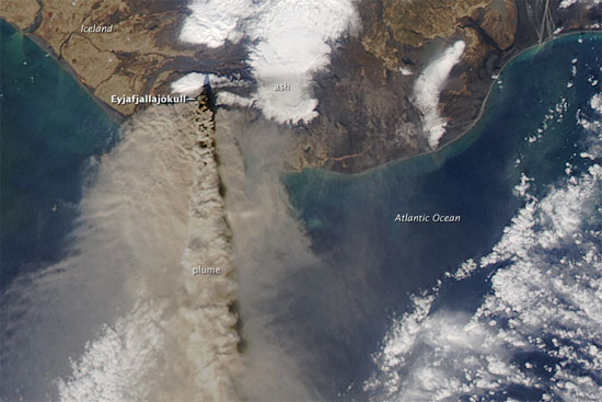
Eyjafjallajökull, a volcano on the Eastern Volcanic Zone in southern Iceland, began to erupt on 14 April 2010.
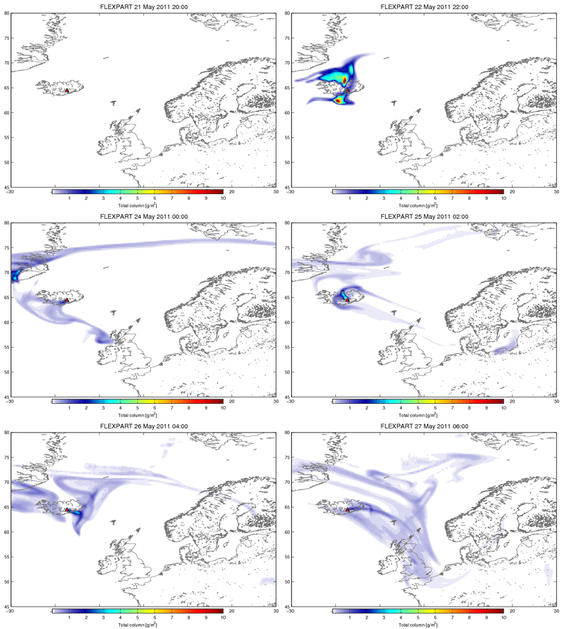
A plume of volcanic ash was at times ejected several kilometres into the atmosphere by this eruption, potentially causing a hazard for aeroplanes. UK airspace was closed from 15–20 April, causing significant disruption, and was reopened following new guidelines about ash densities that could be tolerated by aircraft.
Occasional disruption continued when increased explosive activity at the volcano coincided with northerly to north-westerly winds that brought the ash towards Europe.
The first eruption, on 20 March 2010, came from an ice-free area on the north-east side of the volcano, which is 1660 m high (5300 feet), with an ice cap on the upper slopes. This first phase of eruption produced lava, with little explosive activity. A subsequent phase of eruption then began in a 2.5 km-wide caldera beneath the ice cap near the summit of the volcano on 14 April. This eruption caused melting of large amounts of ice, leading to flooding in southern Iceland. Researchers at the University of Iceland estimated that there was around 1 km3 of ice in the summit crater and that about 25 per cent of this was melted in the first two days of the eruption. The interaction of magma with water created a plume of volcanic ash and gas over 10 km (33 000 feet) high, which spread out and was carried by winds south-eastwards towards the Faroe Islands, Norway, and northern Scotland.
On Sunday 18 April researchers from the University of Iceland estimated that about 750 tonnes of magma were ejected from the volcano every second. By 20 April, most of the ice in the crater appeared to have melted, the plume was only reaching heights of up to 4 km (13 100 feet), and the amount of material being ejected into the plume had increased significantly. As the amount of ice available to interact with the magma decreased, the volcano changed from producing ash to mainly producing fire fountains. By the end of April explosive activity had virtually ended, with a weak plume largely made up of steam, but flowing lava had advanced a few kilometres northwards from the crater.
In early May, explosive activity began to increase again, with more ash being ejected into the plume. Plume height was generally around 4–6 km, but reaching at times up to 8–9 km. During the first two weeks of May, the activity became cyclical, and earthquake activity recorded the rise of magma and gas from depth beneath the volcano. The explosive activity was now driven by gas dissolved in the rising magma, rather than by the interaction of magma and water. Explosive activity gradually decreased and by 23 May little or no ash was being ejected from the volcano.
Your browser does not support viewing this document. Click here to download the document.
| The Icelandic volcanic ash hazard, 2010 | |
| File Size: | 412 kb |
| File Type: | |
Landslides
2006 Southern Leyte, Philippines (LIC)
Your browser does not support viewing this document. Click here to download the document.
| GeoActive - Leyte Philippines | |
| File Size: | 223 kb |
| File Type: | |
|
| ||||||||||||
California, 2018 (HIC)
|
|
|
|
|
|
