
Plate tectonic theory
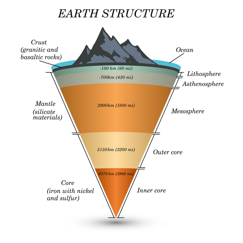
Earth's structure
|
|
|
|
|
| Plate Tectonics GeoActive |
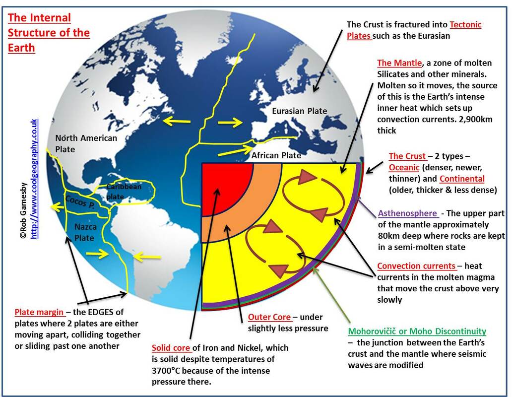
Divergent Movement
Convergent movement
Transform Movement
Intra-plate Volcanism
Types of Volcanoes

Using the PPT, USGS website and YouTube explore the different types of volcanoes.
|
| |||||
Volcanic Hazards
| volcanic_hazards.pdf |
Earthquakes
|
Earthquakes are caused by the sudden release of energy within some limited region of the rocks of the Earth. The energy can be released by elastic strain, gravity, chemical reactions, or even the motion of massive bodies. Of all these the release of elastic strain is the most important cause, because this form of energy is the only kind that can be stored in sufficient quantity in the Earth to produce major disturbances. Earthquakes associated with this type of energy release are called tectonic earthquakes.
Tectonic earthquakes are explained by the so-called elastic rebound theory, formulated by the American geologist Harry Fielding Reid after the San Andreas Fault ruptured in 1906, generating the great San Francisco earthquake. According to the theory, a tectonic earthquake occurs when strains in rock masses have accumulated to a point where the resulting stresses exceed the strength of the rocks, and sudden fracturing results. The fractures propagate rapidly through the rock, usually tending in the same direction and sometimes extending many kilometres along a local zone of weakness. In 1906, for instance, the San Andreas Fault slipped along a plane 430 km (270 miles) long. Along this line the ground was displaced horizontally as much as 6 metres (20 feet). 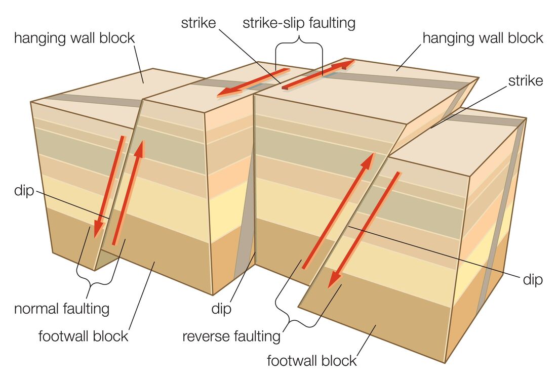
|
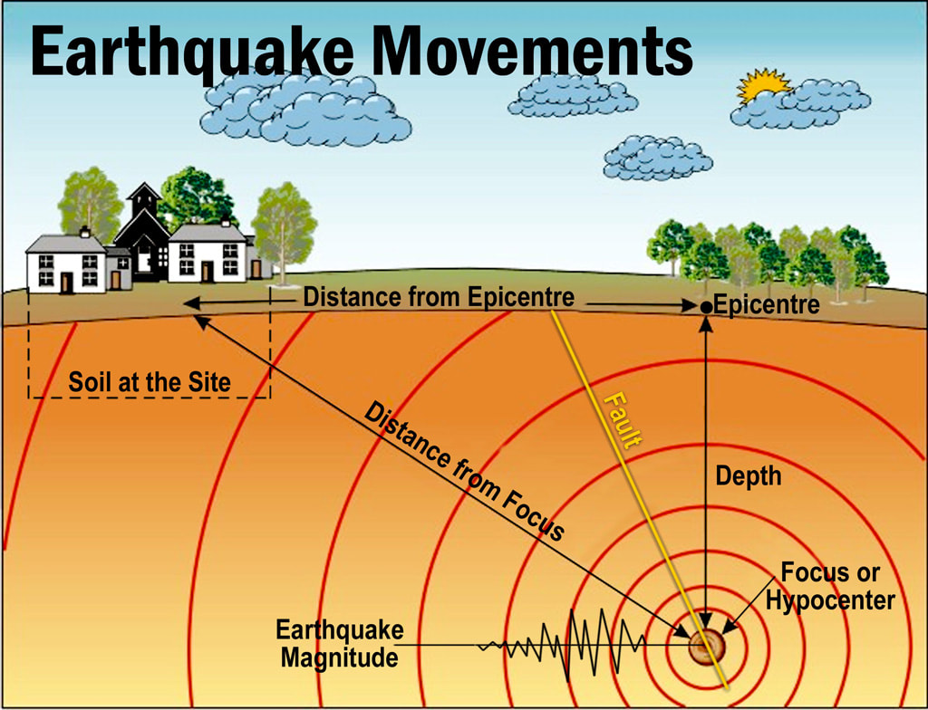
As a fault rupture progresses along or up the fault, rock masses are flung in opposite directions and thus spring back to a position where there is less strain. At any one point this movement may take place not at once but rather in irregular steps; these sudden slowings and restartings give rise to the vibrations that propagate as seismic waves. Such irregular properties of fault rupture are now included in the modeling of earthquake sources, both physically and mathematically. Roughnesses along the fault are referred to as asperities, and places where the rupture slows or stops are said to be fault barriers. Fault rupture starts at the earthquake focus, a spot that in many cases is close to 5–15 km under the surface. The rupture propagates in one or both directions over the fault plane until stopped or slowed at a barrier. Sometimes, instead of being stopped at the barrier, the fault rupture recommences on the far side; at other times the stresses in the rocks break the barrier, and the rupture continues.
Earthquakes have different properties depending on the type of fault slip that causes them . The usual fault model has a “strike” (that is, the direction from north taken by a horizontal line in the fault plane) and a “dip” (the angle from the horizontal shown by the steepest slope in the fault). The lower wall of an inclined fault is called the footwall. Lying over the footwall is the hanging wall. When rock masses slip past each other parallel to the strike, the movement is known as strike-slip faulting. Movement parallel to the dip is called dip-slip faulting. Strike-slip faults are right lateral or left lateral, depending on whether the block on the opposite side of the fault from an observer has moved to the right or left. In dip-slip faults, if the hanging-wall block moves downward relative to the footwall block, it is called “normal” faulting; the opposite motion, with the hanging wall moving upward relative to the footwall, produces reverse or thrust faulting. |
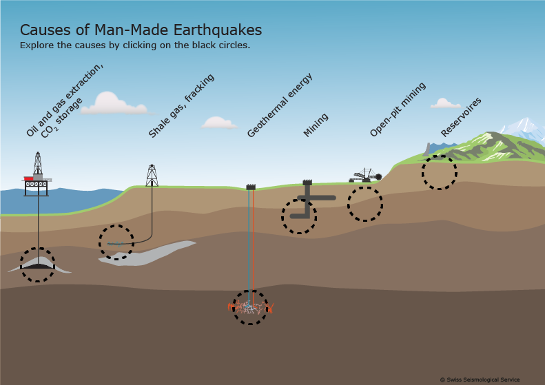
Human induced earthquakes
|

Research: Make notes on the different types of human induced earthquakes - give examples
| ||
Secondary Hazards

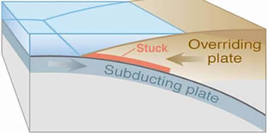
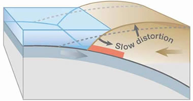
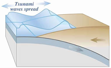
TsunamiMost tsunamis are caused by earthquakes generated in a subduction zone, an area where an oceanic plate is being forced down into the mantle by plate tectonic forces. The friction between the subducting plate and the overriding plate is enormous. This friction prevents a slow and steady rate of subduction and instead the two plates become "stuck.
As the stuck plate continues to descend into the mantle, the motion causes a slow distortion of the overriding plate. The result is an accumulation of energy very similar to the energy stored in a compressed spring. Energy can accumulate in the overriding plate over a long period of time - decades or even centuries. Energy accumulates in the overriding plate until it exceeds the frictional forces between the two stuck plates. When this happens, the overriding plate snaps back into an unrestrained position. This sudden motion is the cause of the tsunami - because it gives an enormous shove to the overlying water. At the same time, inland areas of the overriding plate are suddenly lowered. The moving wave begins travelling out from where the earthquake has occurred. Some of the water travels out and across the ocean basin, and at the same time, water rushes landward to flood the recently lowered shoreline. Many people have the mistaken belief that tsunamis are single waves. They are not. Instead tsunamis are "wave trains" consisting of multiple waves. The chart on this page is a tidal gauge record from Onagawa, Japan beginning at the time of the 1960 Chile earthquake. Time is plotted along the horizontal axis and water level is plotted on the vertical axis. Note the normal rise and fall of the ocean surface, caused by tides, during the early part of this record. Then recorded are a few waves a little larger than normal followed by several much larger waves. In many tsunami events, the shoreline is pounded by repeated large waves
|
Complete the worksheet
| ||||

Liquefaction
|
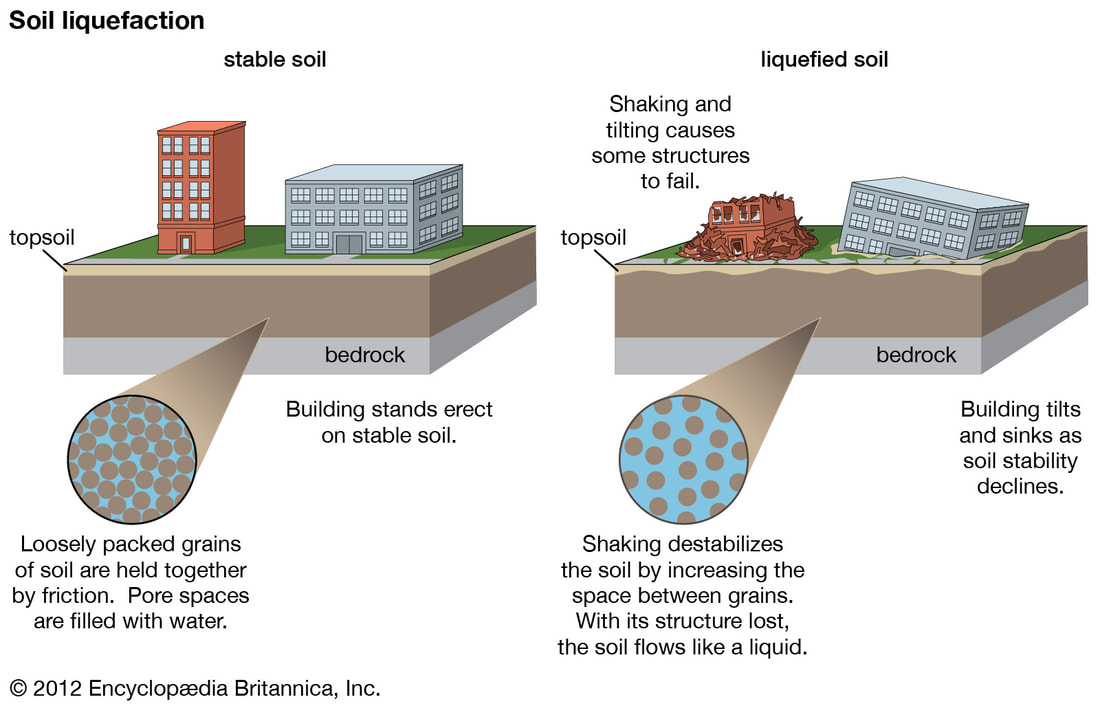
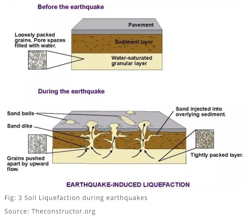
Soil liquefaction, also called earthquake liquefaction, ground failure or loss of strength that causes otherwise solid soil to behave temporarily as a viscous liquid. The phenomenon occurs in water-saturated unconsolidated soils affected by seismic S waves (secondary waves), which cause ground vibrations during earthquakes. Although earthquake shock is the best known cause of liquefaction, certain construction practices, including blasting and soil compaction and vibroflotation (which uses a vibrating probe to change the grain structure of the surrounding soil), produce this phenomenon intentionally. Poorly drained fine-grained soils such as sandy, silty, and gravelly soils are the most susceptible to liquefaction.
Granular soils are made up of a mix of soil and pore spaces. When earthquake shock occurs in waterlogged soils, the water-filled pore spaces collapse, which decreases the overall volume of the soil. This process increases the water pressure between individual soil grains, and the grains can then move freely in the watery matrix. This substantially lowers the soil’s resistance to shear stress and causes the mass of soil to take on the characteristics of a liquid. In its liquefied state, soil deforms easily, and heavy objects such as structures can be damaged from the sudden loss of support from below. Buildings constructed on loose soil pitch and tilt easily when liquefaction occurs, since the soil no longer supports the structures’ foundations. In contrast, structures anchored to bedrock or stiff soils in earthquake-prone areas suffer less damage, because less vibration is transmitted through the foundation to the structure above. In addition, buildings anchored to bedrock have a reduced risk of pitching and tilting. |
|
Transverse faults
A fault that strikes obliquely or perpendicular to the general structural trend of the region.

|
|
|
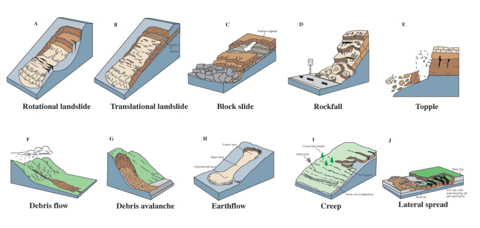
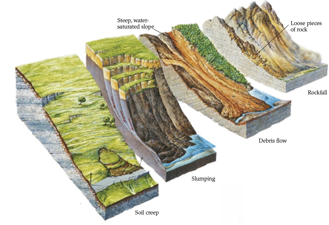
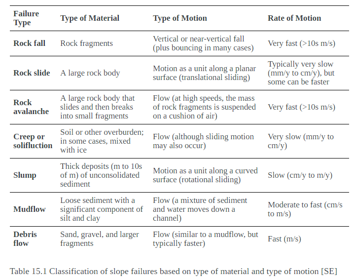
Mass movement
|
| ||
