THE GEOGRAPHER ONLINE

Rivers

  • Home
    • How to make a website: Tools and experiences
    • Maps and Regions
    • Travel Photographs and Videos
    • Live: Global Hazards and Disasters
    • Geography in the news
    • The Big Geography Challenge
  • New IB Geography 2017 onwards
    • IB Geography Introduction
    • Part 1: Geographical Themes >
      • Option B: Oceans and coastal margins >
        • 1. Ocean–atmosphere interactions
        • 2. Interactions between oceans and coastal places
        • 3. Managing coastal margins
        • 4. Ocean management futures
      • Option D: Geophysical Hazards >
        • 1. Geophysical systems
        • 2. Geophysical hazard risks
        • 3. Hazard risk and vulnerability
        • 4. Future resilience and adaptation
    • Part 2: Core Units (SL&HL) >
      • Unit 1: Changing Population >
        • 1. Population and economic development patterns
        • 2. Changing Populations and Places
        • 3. Challenges and opportunities
      • Unit 2: Global climate—vulnerability and resilience >
        • 1. Causes of global climate change
        • 2. Consequences of global climate change
        • 3. Responding to global climate change
      • Unit 3: Global resource consumption and security >
        • 1: Global trends in consumption
        • 2: Impacts of changing trends in resource consumption
        • 3: Resource stewardship
    • Part 3: HL Core Extensions >
      • Unit 4: Power, places and networks >
        • 1. Global interactions and global power
      • Unit 5: Human development and diversity
      • Unit 6: Global risks and resilience
    • Internal Assessment
    • Why should I study IB Geography?
  • IB Geography (Old Syllabus)
    • IB Core >
      • 1. Populations in Transition
      • 2. Disparities in Wealth and Development
      • 3. Patterns in Environmental Quality and Sustainability
      • 4. Patterns in Resource Consumption
    • Part 1: Geographical Themes >
      • Oceans and their Coastal Margins
      • Hazards and disasters - risk assessment and response
      • Freshwater - issues and conflicts
      • Urban Environments
    • Global Interactions - HL >
      • Measuring Global Interactions
      • Changing Space - The Shrinking world
      • Economic Interactions and Flows
      • Environmental Change
      • Sociocultural Exchanges
      • Political Outcomes
      • Global Interactions at the Local Level
    • IB Guidance >
      • Syllabus Guidance
      • IB Examination Guidance
    • Extended Essay
  • IGCSE Geography
    • Theme 1: Population and settlement >
      • Population Dynamics
      • Migration
      • Settlements
      • Urban Settlements
      • Urbanisation
    • Theme 2: The natural environment >
      • Plate Tectonics
      • Coasts
      • Rivers
      • Weather and Climate
      • Climate and Ecosystems
    • Theme 3: Economic development >
      • Development
      • Food Production
      • Industry
      • Energy
      • Tourism
      • Water
      • Environmental Risks of Economic development
    • GCSE Key Terms
    • GCSE Coursework
    • Alternative to Coursework
    • IGCSE Geography Examination Advice
    • IGCSE Revision Games
  • Key Stage 3
    • Year 6 >
      • My Place
      • Rivers
      • Brazil
    • Year 7 >
      • Maps and the world
      • Rocky Landscapes
      • Settlement
      • Weather & Climate
    • Year 8 >
      • Maps Introduction
      • Plate Tectonics
      • Economic Activity
      • Biomes
    • Year 9 >
      • Map Skills - review
      • Development
      • Coasts
      • Tourism
      • Paradise lost - Tourism in Thailand
  • AS Level Geography
    • World at Risk
    • Crowded Coasts
  • Geography Skills
  • Donations & Contact
  • YouTube Channel
  • Essential computer programs

Lesson 1: What are Rivers?

Picture
  • To discover what rivers are and what they look like.
  • To understand and be able to use key terms.
  • To correctly label a river.

Picture
Whilst watching the video below see if you can quickly write down all the new words that we hear in this video.

Picture
Using the template and the slideshare below - label all the major areas in a river.
Rivers introduction from Steven Heath
Rivers Introduction
File Size: 2272 kb
File Type: ppt
Download File

The river course
File Size: 587 kb
File Type: pdf
Download File

The River course - answers
File Size: 549 kb
File Type: pdf
Download File


Picture
Using Plickers review some of the words and ideas learnt.
Plickers

Lesson 2: The Water Cycle

Picture
  • To be able to label a water cycle diagram.
  • To understand how the water cycle moves on our planet.
  • To use water cycle key terms in explanatory sentances

Picture
Watch the following YouTube to discover what the water cycle is.

Picture
Label the following diagram and then glue it in your notebook.
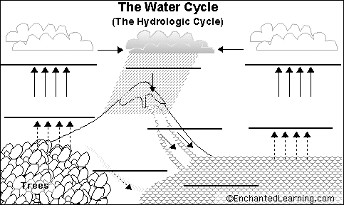
Picture
Water cycle diagram

Picture
Try to explain the water cycle in your own words but using the key terms that we have just discovered. 

Lesson 3: Meanders and Oxbow lakes

Picture
  • To recognize some of the major rivers in the world
  • To be able to explain and draw a meander diagram

Picture
Complete the major river worksheet below. Glue it into your notebook.
Major Rivers
File Size: 49 kb
File Type: doc
Download File


Picture
Key terms:
  • Meander: Is the winding and curving of a river channel.
  • Oxbow lake: Is part of the river left behind after extreme meandering.
  • Erosion: The breakdown and removal of rocks and sediment.
  • Sediment: Any broken down rock or soil carried by a river.
Meanders and Ox-Bow lakes
File Size: 14853 kb
File Type: pptx
Download File

The formation of a Meander & Oxbox lake


Picture
Prepare for a test on River features.

Lesson 4: From Source to Mouth - River Severn

Picture
  • To understand how all the parts of the river fit together
  • To be able to extract notes from a video

Picture
Using the worksheet and YouTube answer the questions
River Severn Worksheet
File Size: 13 kb
File Type: docx
Download File

videoplayback.mp4
File Size: 31378 kb
File Type: mp4
Download File


Picture
Complete the Quizizz review
KS3 Rivers

Lesson 5: River Floods 

Picture
  • To understand what a flood is.
  • To recognize the causes of floods.
  • To explore some of the impacts that floods have on people and the environment.

Picture
Using the video below create a definition for floods

Picture
Group Project:
Your task is to research and create a collage poster that is informing people about floods. It should cover:
  • What are floods.
  • What types of things cause floods?
  • A real life example of a river flood.
  • Why are floods dangerous?
To be able to get good marks your project must be detailed. Written in clear bullet points and also be creative. I expect you to use colour and have diagrams and images to complement your work.

Some sources for you to use

Using the Geog.1 Textbook study the section on floods.
What is a flood 
​Website
Floods
File Size: 453 kb
File Type: pdf
Download File

Marking a poster
File Size: 34 kb
File Type: doc
Download File


Lesson 6&7: Creating a case study

Picture
  • To understand what case studies are and why they are important.
  • To research a real life river.
  • To create a case study report on a real life river.

Picture
Have a class discussion about what they think a case study is. Ask the class why they think it might be important to be able to talk about a real life example. 

Define the term 'Case Study' and outline why they are important in Geography.

Picture
Watch the first 10 minutes of the following documentary as an introduction to the Amazon River
Case Study: Amazon River
Your task will be to research the Amazon River and to answer the following questions as a case study report. The maximum length should be 2 sides of A4 paper. The case study report should be done using computers and then printed. 
  1. Using a map locate the Amazon River and then describe its location.
  2. Provide some facts about the Amazon River
    1. Where does it start?
    2. How long is it?
    3. How many countries does it pass through?
    4. How much water does it transport
    5. etc
  3. Explain why the Amazon River is important to Brazil
    1. What does it provide for people
    2. Do people live on it? Who are they?
  4. How are we damaging the Amazon River - what are people doing to it?
  5. How are we trying to protect it?
    1. Give example of organisations that are working to preserve it and what they are doing.
​
REMEMBER: Alway in a case study use short sentences or bulletpoints  NOT paragraphs. Include images and maps when needed. 
www.thegeographeronline.net
Picture
The Geographer Online is an educational website aimed at providing geography teaching resources for all levels. 
Created and Developed by: Steven Heath

Follow us!
Creative Commons Licence
This work is licensed under a Creative Commons Attribution-NonCommercial-ShareAlike 4.0 International License.
  • Home
    • How to make a website: Tools and experiences
    • Maps and Regions
    • Travel Photographs and Videos
    • Live: Global Hazards and Disasters
    • Geography in the news
    • The Big Geography Challenge
  • New IB Geography 2017 onwards
    • IB Geography Introduction
    • Part 1: Geographical Themes >
      • Option B: Oceans and coastal margins >
        • 1. Ocean–atmosphere interactions
        • 2. Interactions between oceans and coastal places
        • 3. Managing coastal margins
        • 4. Ocean management futures
      • Option D: Geophysical Hazards >
        • 1. Geophysical systems
        • 2. Geophysical hazard risks
        • 3. Hazard risk and vulnerability
        • 4. Future resilience and adaptation
    • Part 2: Core Units (SL&HL) >
      • Unit 1: Changing Population >
        • 1. Population and economic development patterns
        • 2. Changing Populations and Places
        • 3. Challenges and opportunities
      • Unit 2: Global climate—vulnerability and resilience >
        • 1. Causes of global climate change
        • 2. Consequences of global climate change
        • 3. Responding to global climate change
      • Unit 3: Global resource consumption and security >
        • 1: Global trends in consumption
        • 2: Impacts of changing trends in resource consumption
        • 3: Resource stewardship
    • Part 3: HL Core Extensions >
      • Unit 4: Power, places and networks >
        • 1. Global interactions and global power
      • Unit 5: Human development and diversity
      • Unit 6: Global risks and resilience
    • Internal Assessment
    • Why should I study IB Geography?
  • IB Geography (Old Syllabus)
    • IB Core >
      • 1. Populations in Transition
      • 2. Disparities in Wealth and Development
      • 3. Patterns in Environmental Quality and Sustainability
      • 4. Patterns in Resource Consumption
    • Part 1: Geographical Themes >
      • Oceans and their Coastal Margins
      • Hazards and disasters - risk assessment and response
      • Freshwater - issues and conflicts
      • Urban Environments
    • Global Interactions - HL >
      • Measuring Global Interactions
      • Changing Space - The Shrinking world
      • Economic Interactions and Flows
      • Environmental Change
      • Sociocultural Exchanges
      • Political Outcomes
      • Global Interactions at the Local Level
    • IB Guidance >
      • Syllabus Guidance
      • IB Examination Guidance
    • Extended Essay
  • IGCSE Geography
    • Theme 1: Population and settlement >
      • Population Dynamics
      • Migration
      • Settlements
      • Urban Settlements
      • Urbanisation
    • Theme 2: The natural environment >
      • Plate Tectonics
      • Coasts
      • Rivers
      • Weather and Climate
      • Climate and Ecosystems
    • Theme 3: Economic development >
      • Development
      • Food Production
      • Industry
      • Energy
      • Tourism
      • Water
      • Environmental Risks of Economic development
    • GCSE Key Terms
    • GCSE Coursework
    • Alternative to Coursework
    • IGCSE Geography Examination Advice
    • IGCSE Revision Games
  • Key Stage 3
    • Year 6 >
      • My Place
      • Rivers
      • Brazil
    • Year 7 >
      • Maps and the world
      • Rocky Landscapes
      • Settlement
      • Weather & Climate
    • Year 8 >
      • Maps Introduction
      • Plate Tectonics
      • Economic Activity
      • Biomes
    • Year 9 >
      • Map Skills - review
      • Development
      • Coasts
      • Tourism
      • Paradise lost - Tourism in Thailand
  • AS Level Geography
    • World at Risk
    • Crowded Coasts
  • Geography Skills
  • Donations & Contact
  • YouTube Channel
  • Essential computer programs