THE GEOGRAPHER ONLINE

Maps

  • Home
    • How to make a website: Tools and experiences
    • Maps and Regions
    • Travel Photographs and Videos
    • Live: Global Hazards and Disasters
    • Geography in the news
    • The Big Geography Challenge
  • New IB Geography 2017 onwards
    • IB Geography Introduction
    • Part 1: Geographical Themes >
      • Option B: Oceans and coastal margins >
        • 1. Ocean–atmosphere interactions
        • 2. Interactions between oceans and coastal places
        • 3. Managing coastal margins
        • 4. Ocean management futures
      • Option D: Geophysical Hazards >
        • 1. Geophysical systems
        • 2. Geophysical hazard risks
        • 3. Hazard risk and vulnerability
        • 4. Future resilience and adaptation
    • Part 2: Core Units (SL&HL) >
      • Unit 1: Changing Population >
        • 1. Population and economic development patterns
        • 2. Changing Populations and Places
        • 3. Challenges and opportunities
      • Unit 2: Global climate—vulnerability and resilience >
        • 1. Causes of global climate change
        • 2. Consequences of global climate change
        • 3. Responding to global climate change
      • Unit 3: Global resource consumption and security >
        • 1: Global trends in consumption
        • 2: Impacts of changing trends in resource consumption
        • 3: Resource stewardship
    • Part 3: HL Core Extensions >
      • Unit 4: Power, places and networks >
        • 1. Global interactions and global power
      • Unit 5: Human development and diversity
      • Unit 6: Global risks and resilience
    • Internal Assessment
    • Why should I study IB Geography?
  • IB Geography (Old Syllabus)
    • IB Core >
      • 1. Populations in Transition
      • 2. Disparities in Wealth and Development
      • 3. Patterns in Environmental Quality and Sustainability
      • 4. Patterns in Resource Consumption
    • Part 1: Geographical Themes >
      • Oceans and their Coastal Margins
      • Hazards and disasters - risk assessment and response
      • Freshwater - issues and conflicts
      • Urban Environments
    • Global Interactions - HL >
      • Measuring Global Interactions
      • Changing Space - The Shrinking world
      • Economic Interactions and Flows
      • Environmental Change
      • Sociocultural Exchanges
      • Political Outcomes
      • Global Interactions at the Local Level
    • IB Guidance >
      • Syllabus Guidance
      • IB Examination Guidance
    • Extended Essay
  • IGCSE Geography
    • Theme 1: Population and settlement >
      • Population Dynamics
      • Migration
      • Settlements
      • Urban Settlements
      • Urbanisation
    • Theme 2: The natural environment >
      • Plate Tectonics
      • Coasts
      • Rivers
      • Weather and Climate
      • Climate and Ecosystems
    • Theme 3: Economic development >
      • Development
      • Food Production
      • Industry
      • Energy
      • Tourism
      • Water
      • Environmental Risks of Economic development
    • GCSE Key Terms
    • GCSE Coursework
    • Alternative to Coursework
    • IGCSE Geography Examination Advice
    • IGCSE Revision Games
  • Key Stage 3
    • Year 6 >
      • My Place
      • Rivers
      • Brazil
    • Year 7 >
      • Maps and the world
      • Rocky Landscapes
      • Settlement
      • Weather & Climate
    • Year 8 >
      • Maps Introduction
      • Plate Tectonics
      • Economic Activity
      • Biomes
    • Year 9 >
      • Map Skills - review
      • Development
      • Coasts
      • Tourism
      • Paradise lost - Tourism in Thailand
  • AS Level Geography
    • World at Risk
    • Crowded Coasts
  • Geography Skills
  • Donations & Contact
  • YouTube Channel
  • Essential computer programs

Lesson 1 : Introducing Geography

Picture
Objectives​
•To know what the study of geography involves. 
•To understand the difference between physical and human geography and where they overlap, environmental geography. 
•To be able to classify different topics into these categories


Picture

​Starter:
Watch the following YouTube and find 3 things that you think make Geography really matter. 


Picture

​Main activities:
 

Human, Physical and Environmental Geography
File Size: 3839 kb
File Type: pptx
Download File

​After reviewing the PowerPoint you can use the content to create a poster.
Poster
  1. Think about the images we discussed last lesson, and the main types of Geography (Physical, Environmental, Human) as well as the various topics one might study in Geography (Coasts, Cities, Tourism, Rivers, etc. etc.)
  2. Using the A3 sheet of paper, create a full scale poster to answer the question What is Geography? and help to define the subject
  • Take care with drawing and titles
  • Keep it neat
  • Lots of drawings
  • Lots of colour! 
  • Lots of geographical ideas and key words
I would like to display these on the back wall of the room (they will be what people see when they come in!) so make them as eye-catching and interesting as you can.

To be completed for Homework.
[10 Marks]
5 Content - Make sure that you include lots of key geography words and that your sentences are accurate.
2 Presentation - Clear design and neatly presented using colours and titles.
3 Drawings - You will need to include little drawings to illustrate your ideas.

Picture

Tell me three things that you have learnt in this lesson that you did not know before?
3-2-1_plenary.pdf
File Size: 48 kb
File Type: pdf
Download File


Lesson 2: ​What are maps? - Exploring China

Picture
  • To consider the importance of maps.
  • To compare different types of maps.
  • To identify who uses maps.
  • To be able to make a map using the principles of STACK

Picture

​Explore the YouTube on maps and consider what types of maps we have?

Picture
Main:
Complete the a PowerPoint below and the activities included.

Types of Maps - Activity sheet
File Size: 53 kb
File Type: pdf
Download File

All about maps
File Size: 17132 kb
File Type: ppt
Download File

Continets and Oceans worksheet
File Size: 160 kb
File Type: docx
Download File

China Map Outline
File Size: 99 kb
File Type: docx
Download File


Picture
​Complete the Map Quiz at the end of the PowerPoint


Lesson 3: ​Around THE WORLD

Picture
  • To know the continents and oceans of the world.
  • To be able to locate all the continents and oceans on a world map
  • To be able to use an Atlas

Picture
Introduction to Atlases 
Maps and Atlases
File Size: 369 kb
File Type: pptx
Download File


Picture

​Complete the following worksheets:
  • Continents and Oceans of the World
  • Atlas Scavenger hunt

Continents and Oceans of the world
File Size: 161 kb
File Type: docx
Download File

Atlas Scavenger Hunt
File Size: 222 kb
File Type: docx
Download File

Atlas Scavenger Hunt - Answer sheet
File Size: 19 kb
File Type: docx
Download File


Picture

​Test each other on finding locations using the Atlases.


Lesson 4: Discovering China

Picture
  • To appreciate the geography of China
  • To be able to locate important physical features in and around China.

Picture
Using laptops and the atlases complete a brief fact sheet on China.
China Factsheet - template
File Size: 34 kb
File Type: pdf
Download File


Picture

​Complete the following worksheet with the help of the Atlases and the laptops.
The final map should:

  1. Have the 3 major rivers labeled (The Pearl River will need to be added)
  2. Include the Altai and Himalayan mountain ranges.
  3. Show the Gobi and Takla Makan desert.

Activity Sheet - Mapping China
File Size: 2494 kb
File Type: docx
Download File


Picture

Test you area knowledge, play the Quiz Game

Quizziz Game China


Lesson 5: Latitude and Longitude

Picture
  • To know what latitude and longitude mean
  • To understand how to use them
  • To be able to use them to locate places around the world

Picture

​Watch the YouTube below about longitude and latitude. 
Do you know what they mean?


Picture

Go through the PowerPoint discussing lines of latitude and longitude.
​Then complete the worksheets found below.

latitude_and_longitude.ppt
File Size: 2032 kb
File Type: ppt
Download File

Latitude and Longitude Worksheet
File Size: 136 kb
File Type: docx
Download File

Practice using lines of latitude and longitude - worksheet
File Size: 56 kb
File Type: doc
Download File

Latitude and Longitude Map practice
File Size: 286 kb
File Type: pdf
Download File

Extension activity - Trip around the world
File Size: 32 kb
File Type: doc
Download File


Picture

Using the atlases ask students to test each other on places that they have been on holiday. Can they find out where each other went using lines of latitude and longitude? 

Latitude and Longitude Review
File Size: 64 kb
File Type: pdf
Download File


Lesson 6: OS Map Symbols

Picture

  • ​To know the basic map symbols used
  • To understand why we use them
  • To be able to interpret and use them


Picture

Using the image below discuss what symbols are and why we use them. Can you guess the meaning of some of the symbols?

Picture

Picture

​Use the introductory PowerPoint to explain OS Symbols. Ensure that all students have an OS Map in front of them.

Map Symbols
File Size: 1268 kb
File Type: ppt
Download File

OS Map Symbols
File Size: 866 kb
File Type: pdf
Download File


Picture

​Print off the bingo cards and Play Map Bingo. When reviewing the answers encourage students to identify the symbol that appears.

Bingo Cards
File Size: 21 kb
File Type: pdf
Download File

Bingo Game
File Size: 985 kb
File Type: ppt
Download File

Snap Game for use with iPads

Lesson 7: Compass Directions

Picture

  • ​To know the points of the 16 point compass
  • To be able to use it to describe where things are


Picture

​Watch the Compass Rose song to identify the main points of direction.


Picture


​Draw and label the Compass below.

Picture
Picture

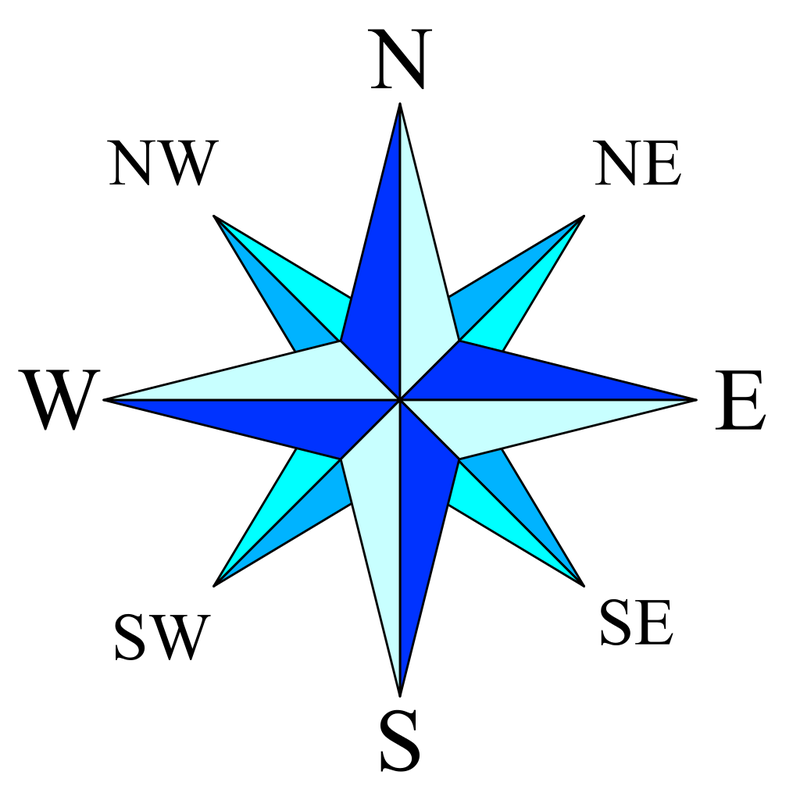
​Complete the following worksheets.

maptown_zoo_activity_sheet.pdf
File Size: 407 kb
File Type: pdf
Download File

Points on a compass worksheet
File Size: 107 kb
File Type: pdf
Download File

Points on a compass - Answers
File Size: 129 kb
File Type: pdf
Download File


Picture

​Play the following interactive game and Kahoot.

Kahoot
Picture

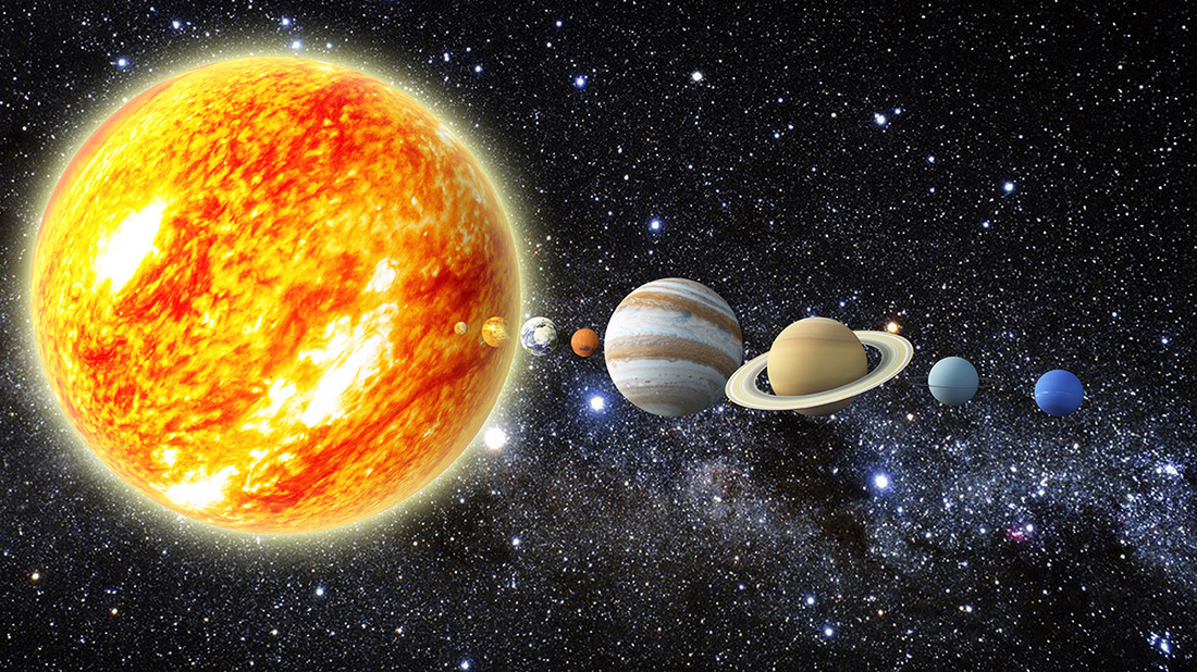
Lesson 8: Scale and Distance

Picture
​
  • To know the three types of scale used on maps
  • To understand how scale relates to distance 
  • To be able to measure distances on a map using a range of scales


Picture

​Look at the following image. What is it?
What can we tell from it?

Then watch the YouTube. Does it change your concept of size?

Picture

Picture
​Map scale refers to the relationship (or ratio) between distance on a map and the corresponding distance on the ground. For example, on a 1:100000 scale map, 1cm on the map equals 1km on the ground.
Picture

​Complete the following worksheet.

Scale worksheet
File Size: 29 kb
File Type: pdf
Download File


Picture

​Look at the image of a box and decide what scale should be used. Then draw it 'unpacked' to scale.
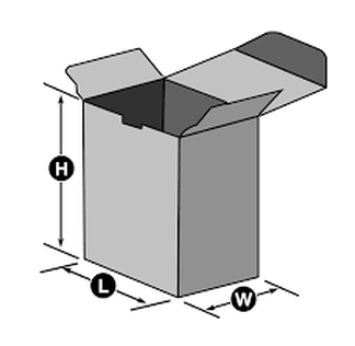
Picture
Dimensions:
  • Height = 24m
  • Length = 12m
  • Width = 6m


Lesson 9: Grid Referencds

Picture

  • ​To know what grid references are and when to use them
  • To be able to use 4 and 6 figure grid references


Picture

​Review previous lesson on lines of Latitude and Longitude. 
What are they?
How do we use them?


Picture

​Using the Following PowerPoint make notes on how we use Grid References.

Grid References Lesson
File Size: 948 kb
File Type: ppt
Download File

Complete the following worksheet
​
Swanage Map Activity - Grid References
File Size: 265 kb
File Type: pdf
Download File


Picture

​Play the following Kahoot to test 6 Figure knowledge or Play Battleships.

Battleships
File Size: 75 kb
File Type: pdf
Download File

Battleships instructions
File Size: 365 kb
File Type: pdf
Download File

6 Figure Grid Ref Kahoot

Lesson 10: Height and Relief

Picture

  • To be able to identify height on a map
  • To understand how to read height
  • To know how contour lines represent shape.


Picture
Watch the following YouTube. What do you think Altitude and relief represents? 
Can you tell me one way we show this on a map?


Picture
Using the PowerPoint create some notes on Altitude and Relief.
Height and Relief
File Size: 21717 kb
File Type: pptx
Download File

Complete the following worksheets
Relief Activity Sheet
File Size: 299 kb
File Type: pdf
Download File

Relief Answer Sheet
File Size: 315 kb
File Type: pdf
Download File


Picture

Draw a cross section showing relief.


How to draw a cross section
File Size: 1148 kb
File Type: pdf
Download File

Cross section graph
File Size: 541 kb
File Type: pdf
Download File

Map/Contour lines for cross section
File Size: 320 kb
File Type: pdf
Download File


Lesson 11: Review of skills

Assessment Map Skills Review
File Size: 578 kb
File Type: pdf
Download File

Assessment Map Skills Review - Answers
File Size: 595 kb
File Type: pdf
Download File

www.thegeographeronline.net
Picture
The Geographer Online is an educational website aimed at providing geography teaching resources for all levels. 
Created and Developed by: Steven Heath

Follow us!
Creative Commons Licence
This work is licensed under a Creative Commons Attribution-NonCommercial-ShareAlike 4.0 International License.
  • Home
    • How to make a website: Tools and experiences
    • Maps and Regions
    • Travel Photographs and Videos
    • Live: Global Hazards and Disasters
    • Geography in the news
    • The Big Geography Challenge
  • New IB Geography 2017 onwards
    • IB Geography Introduction
    • Part 1: Geographical Themes >
      • Option B: Oceans and coastal margins >
        • 1. Ocean–atmosphere interactions
        • 2. Interactions between oceans and coastal places
        • 3. Managing coastal margins
        • 4. Ocean management futures
      • Option D: Geophysical Hazards >
        • 1. Geophysical systems
        • 2. Geophysical hazard risks
        • 3. Hazard risk and vulnerability
        • 4. Future resilience and adaptation
    • Part 2: Core Units (SL&HL) >
      • Unit 1: Changing Population >
        • 1. Population and economic development patterns
        • 2. Changing Populations and Places
        • 3. Challenges and opportunities
      • Unit 2: Global climate—vulnerability and resilience >
        • 1. Causes of global climate change
        • 2. Consequences of global climate change
        • 3. Responding to global climate change
      • Unit 3: Global resource consumption and security >
        • 1: Global trends in consumption
        • 2: Impacts of changing trends in resource consumption
        • 3: Resource stewardship
    • Part 3: HL Core Extensions >
      • Unit 4: Power, places and networks >
        • 1. Global interactions and global power
      • Unit 5: Human development and diversity
      • Unit 6: Global risks and resilience
    • Internal Assessment
    • Why should I study IB Geography?
  • IB Geography (Old Syllabus)
    • IB Core >
      • 1. Populations in Transition
      • 2. Disparities in Wealth and Development
      • 3. Patterns in Environmental Quality and Sustainability
      • 4. Patterns in Resource Consumption
    • Part 1: Geographical Themes >
      • Oceans and their Coastal Margins
      • Hazards and disasters - risk assessment and response
      • Freshwater - issues and conflicts
      • Urban Environments
    • Global Interactions - HL >
      • Measuring Global Interactions
      • Changing Space - The Shrinking world
      • Economic Interactions and Flows
      • Environmental Change
      • Sociocultural Exchanges
      • Political Outcomes
      • Global Interactions at the Local Level
    • IB Guidance >
      • Syllabus Guidance
      • IB Examination Guidance
    • Extended Essay
  • IGCSE Geography
    • Theme 1: Population and settlement >
      • Population Dynamics
      • Migration
      • Settlements
      • Urban Settlements
      • Urbanisation
    • Theme 2: The natural environment >
      • Plate Tectonics
      • Coasts
      • Rivers
      • Weather and Climate
      • Climate and Ecosystems
    • Theme 3: Economic development >
      • Development
      • Food Production
      • Industry
      • Energy
      • Tourism
      • Water
      • Environmental Risks of Economic development
    • GCSE Key Terms
    • GCSE Coursework
    • Alternative to Coursework
    • IGCSE Geography Examination Advice
    • IGCSE Revision Games
  • Key Stage 3
    • Year 6 >
      • My Place
      • Rivers
      • Brazil
    • Year 7 >
      • Maps and the world
      • Rocky Landscapes
      • Settlement
      • Weather & Climate
    • Year 8 >
      • Maps Introduction
      • Plate Tectonics
      • Economic Activity
      • Biomes
    • Year 9 >
      • Map Skills - review
      • Development
      • Coasts
      • Tourism
      • Paradise lost - Tourism in Thailand
  • AS Level Geography
    • World at Risk
    • Crowded Coasts
  • Geography Skills
  • Donations & Contact
  • YouTube Channel
  • Essential computer programs