THE GEOGRAPHER ONLINE

Settlements

  • Home
    • How to make a website: Tools and experiences
    • Maps and Regions
    • Travel Photographs and Videos
    • Live: Global Hazards and Disasters
    • Geography in the news
    • The Big Geography Challenge
  • New IB Geography 2017 onwards
    • IB Geography Introduction
    • Part 1: Geographical Themes >
      • Option B: Oceans and coastal margins >
        • 1. Ocean–atmosphere interactions
        • 2. Interactions between oceans and coastal places
        • 3. Managing coastal margins
        • 4. Ocean management futures
      • Option D: Geophysical Hazards >
        • 1. Geophysical systems
        • 2. Geophysical hazard risks
        • 3. Hazard risk and vulnerability
        • 4. Future resilience and adaptation
    • Part 2: Core Units (SL&HL) >
      • Unit 1: Changing Population >
        • 1. Population and economic development patterns
        • 2. Changing Populations and Places
        • 3. Challenges and opportunities
      • Unit 2: Global climate—vulnerability and resilience >
        • 1. Causes of global climate change
        • 2. Consequences of global climate change
        • 3. Responding to global climate change
      • Unit 3: Global resource consumption and security >
        • 1: Global trends in consumption
        • 2: Impacts of changing trends in resource consumption
        • 3: Resource stewardship
    • Part 3: HL Core Extensions >
      • Unit 4: Power, places and networks >
        • 1. Global interactions and global power
      • Unit 5: Human development and diversity
      • Unit 6: Global risks and resilience
    • Internal Assessment
    • Why should I study IB Geography?
  • IB Geography (Old Syllabus)
    • IB Core >
      • 1. Populations in Transition
      • 2. Disparities in Wealth and Development
      • 3. Patterns in Environmental Quality and Sustainability
      • 4. Patterns in Resource Consumption
    • Part 1: Geographical Themes >
      • Oceans and their Coastal Margins
      • Hazards and disasters - risk assessment and response
      • Freshwater - issues and conflicts
      • Urban Environments
    • Global Interactions - HL >
      • Measuring Global Interactions
      • Changing Space - The Shrinking world
      • Economic Interactions and Flows
      • Environmental Change
      • Sociocultural Exchanges
      • Political Outcomes
      • Global Interactions at the Local Level
    • IB Guidance >
      • Syllabus Guidance
      • IB Examination Guidance
    • Extended Essay
  • IGCSE Geography
    • Theme 1: Population and settlement >
      • Population Dynamics
      • Migration
      • Settlements
      • Urban Settlements
      • Urbanisation
    • Theme 2: The natural environment >
      • Plate Tectonics
      • Coasts
      • Rivers
      • Weather and Climate
      • Climate and Ecosystems
    • Theme 3: Economic development >
      • Development
      • Food Production
      • Industry
      • Energy
      • Tourism
      • Water
      • Environmental Risks of Economic development
    • GCSE Key Terms
    • GCSE Coursework
    • Alternative to Coursework
    • IGCSE Geography Examination Advice
    • IGCSE Revision Games
  • Key Stage 3
    • Year 6 >
      • My Place
      • Rivers
      • Brazil
    • Year 7 >
      • Maps and the world
      • Rocky Landscapes
      • Settlement
      • Weather & Climate
    • Year 8 >
      • Maps Introduction
      • Plate Tectonics
      • Economic Activity
      • Biomes
    • Year 9 >
      • Map Skills - review
      • Development
      • Coasts
      • Tourism
      • Paradise lost - Tourism in Thailand
  • AS Level Geography
    • World at Risk
    • Crowded Coasts
  • Geography Skills
  • Donations & Contact
  • YouTube Channel
  • Essential computer programs

Lesson 1: Introduction to where we live

Picture
​
  • To know where people live around the world and where the world’s fastest growing cities are.
  • To understand some of the factors affecting population
  • To be able to describe distribution on maps.
​

Picture

​Using Goolge Timelapse of the world. Examine how parts of the world have developed. 
  • What can you see?
  • How have they changed?

Google Timelapse of the world

Picture
Watch the following YouTube. Explore the 10 most populous cities in the world 
Picture
Using the map below colour in your map handout and then describe the distribution of people in the wold
Map handout
File Size: 154 kb
File Type: docx
Download File

Picture


Picture


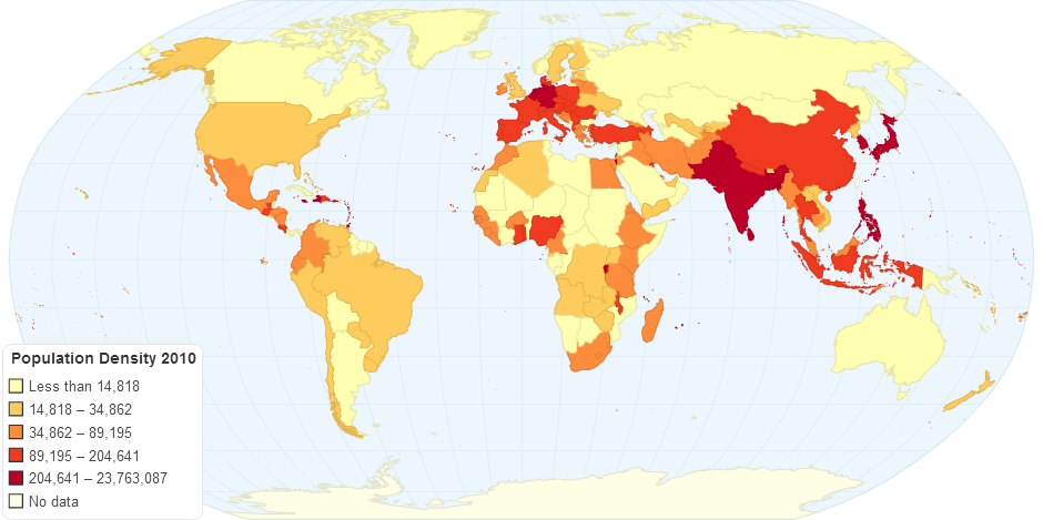
​Discuss why you think the areas on your map have high population densities. Create a spider diagram with reasons.


Lesson 2 & 3: How do settlements start?

Picture

  • To know and understand why humans began to settle in places (agriculture, religion, conflict etc)
  • To know the difference between site and situation
  • To understand how these influence settlements


Picture


​Watch the following video and discuss the reasons for the establishment of settlements.


Picture
Use the SlideShare to define the key points and complete the exercises on the worksheet.
Your browser does not support viewing this document. Click here to download the document.
What did early settlers need?
File Size: 5248 kb
File Type: ppt
Download File

Settlement Worksheet
File Size: 418 kb
File Type: docx
Download File


Picture

Complete the Kahoot knowledge review on settlements.

Kahoot Settlements

Lesson 4: Shape & Function of settlements

Picture
  • To understand what settlement functions are.
  • To be able to categorize settlements into functions
  • To know and identify the shapes of settlements.

Picture
Review the key factors that determine settlement location. Can you remember them all? Brainstorm the ideas.

Picture
Using the handouts identify the different settlement shapes and complete the activities on the Foundations worksheet.
Settlement shape card
File Size: 195 kb
File Type: docx
Download File

Foundations map and activities
File Size: 2433 kb
File Type: pdf
Download File

Settlement: Function and Layout from Steven Heath
Layout and Function of Settlements
File Size: 2059 kb
File Type: ppt
Download File


Picture
Can you guess the concept?
Play a short game of Pictionary to review the key ideas and settlement shapes.

 Lesson 5 & 6: Urban land use

Picture
  • To know what a land use model is.
  • To understand the Burgess Model.
  • To be able to recognize and describe the different zones in a city.

Picture
 Note down (swiftly!) any changes you see happening to the environment. (In particular, think about: Land  use, types of building and building height.)

Picture
  1. Complete the activities on the PowerPoint.
  2. Complete the Burgess and Hoyt Worksheets
  3. Using the worksheet out line create a cartoon outlining all the different sectors of Burgess' model.
Burgess Model Worksheet
File Size: 97 kb
File Type: pdf
Download File

Hoyt Model Worksheet
File Size: 102 kb
File Type: pdf
Download File

Cartoon outline - Handout
File Size: 51 kb
File Type: tif
Download File

Urban Land use from Steven Heath
Urban Land Use PowerPoint
File Size: 3601 kb
File Type: ppt
Download File


Picture
Review your knowledge using the Settlement Kahoot
Settlement Kahoot


Lesson 7 & 8: Rural to Urban Migration

Picture
  • To know what rural to urban migration is and push/pull factors are
  • To understand why people have moved
  • To be able to describe the change over time using China as example

Picture
Use the following video as a stimulus to begin thinking about the causes of Rural to Urban Migration
City growth in China Animation

Picture
Review the following worksheet to examine some of the PUSH and PULL factors that encourage people to migrate from rural areas to urban areas.
Your browser does not support viewing this document. Click here to download the document.
Urbanisation Push/Pull
File Size: 30 kb
File Type: docx
Download File

Video task

You are going to be starting a video  project. The task is to create a short 5 minute video explaining why people from Rural areas want to migrate to Urban areas. This will be done as a news-broadcast using the green-screens. You should:
  • Have at least one News anchor.
  • Explain what urbanization is.
  • Outline some of the push and pull factors.
  • Interview someone from the City/Country side about the reasons/impacts
  • Include pictures etc.
  • This should be based on a China example
Picture

Lesson 9 & 10: Settlement Hierarchies & out of town shopping

Picture
  • To know what a settlement hierarchy is
  • To understand the main characteristics of different types of settlements
  • To know what an Out of Town Shopping Centre is
  • To understand why they have developed

Picture
Complete the 19th Vs. 21st Century Shopper worksheet
Shopping Trends
File Size: 115 kb
File Type: doc
Download File


Picture
Settlement Types
File Size: 86 kb
File Type: pdf
Download File

Settlement Pyramid
File Size: 137 kb
File Type: pdf
Download File

Task:
Using the image to the right complete all the questions in the exercise. (taken from Geog.1 page 41)
What services can be found in each settlement?
Test the students knowledge on service location
Picture
Picture

Using the information found in Geog.1 pages 57 & 58 create a poster to advertise the advantages of out of town shopping centers and the internet. Task should be completed for homework.
Your browser does not support viewing this document. Click here to download the document.

Picture
Complete the worksheet about ways Congestion can be reduced.
Reducing Congestion
File Size: 243 kb
File Type: pdf
Download File


Lesson 11: Sustainable - Houses of the future?

Picture
  • To understand the meaning of the word 'sustainability'
  • To be able to describe and explain ways in which homes can become more sustainable

Picture
What is the meaning of the word 'SUSTAINABLE'? Discuss, what do you think? Why is it important?


'Meeting the needs of today without compromising the ability of future generations to meet their own needs.'

Test your Carbon Footprint
How much do I pollute?

Picture
Using the YouTube below, you will be investigating ways that homes can become more sustainable. You will need to make notes on the following areas:
  1. What technology is used?
  2. How can we change how we live?
Remember this will be linked to a bigger project later, so the quality of your notes will help you with your assessed work in a future lesson.
Building a Sustainable house - activity sheet
File Size: 123 kb
File Type: pdf
Download File


Picture
Review what we have learnt from the video. Together go through some of the key ideas. What can we do, and why do they help our homes be more sustainable?

Lesson 12,13&14: Sustainable Urban environments

Picture
  • To understand why it is necessary for cities to become more sustainable
  • To be able to explain methods that could be used to make our cities more sustainable

Picture
Explore how a city can become more sustainable. Make a note of the key ideas.

Picture
Task:
​How can Hegezhuang be more sustainable?’
  1. Brainstorm ideas on what we could do in our local Hutong to make it more sustainable?
  2. In teams, imagine you have been hired to make a proposition to the Hutong council. You should prepare a presentation outlying how to make the settlement more sustainable.
Some areas you might want to think about are:
* The needs of the community and the villagers.
* The climate – be realistic with energy generation. Is the area windy, sunny or near the sea?
* Transport.
* Procurement of resources.
* Water.
* Waste.
* Leisure areas.
* Accommodation.
* Food production.
* Energy production.
* Conservation of existing environment.
Picture
www.thegeographeronline.net
Picture
The Geographer Online is an educational website aimed at providing geography teaching resources for all levels. 
Created and Developed by: Steven Heath

Follow us!
Creative Commons Licence
This work is licensed under a Creative Commons Attribution-NonCommercial-ShareAlike 4.0 International License.
  • Home
    • How to make a website: Tools and experiences
    • Maps and Regions
    • Travel Photographs and Videos
    • Live: Global Hazards and Disasters
    • Geography in the news
    • The Big Geography Challenge
  • New IB Geography 2017 onwards
    • IB Geography Introduction
    • Part 1: Geographical Themes >
      • Option B: Oceans and coastal margins >
        • 1. Ocean–atmosphere interactions
        • 2. Interactions between oceans and coastal places
        • 3. Managing coastal margins
        • 4. Ocean management futures
      • Option D: Geophysical Hazards >
        • 1. Geophysical systems
        • 2. Geophysical hazard risks
        • 3. Hazard risk and vulnerability
        • 4. Future resilience and adaptation
    • Part 2: Core Units (SL&HL) >
      • Unit 1: Changing Population >
        • 1. Population and economic development patterns
        • 2. Changing Populations and Places
        • 3. Challenges and opportunities
      • Unit 2: Global climate—vulnerability and resilience >
        • 1. Causes of global climate change
        • 2. Consequences of global climate change
        • 3. Responding to global climate change
      • Unit 3: Global resource consumption and security >
        • 1: Global trends in consumption
        • 2: Impacts of changing trends in resource consumption
        • 3: Resource stewardship
    • Part 3: HL Core Extensions >
      • Unit 4: Power, places and networks >
        • 1. Global interactions and global power
      • Unit 5: Human development and diversity
      • Unit 6: Global risks and resilience
    • Internal Assessment
    • Why should I study IB Geography?
  • IB Geography (Old Syllabus)
    • IB Core >
      • 1. Populations in Transition
      • 2. Disparities in Wealth and Development
      • 3. Patterns in Environmental Quality and Sustainability
      • 4. Patterns in Resource Consumption
    • Part 1: Geographical Themes >
      • Oceans and their Coastal Margins
      • Hazards and disasters - risk assessment and response
      • Freshwater - issues and conflicts
      • Urban Environments
    • Global Interactions - HL >
      • Measuring Global Interactions
      • Changing Space - The Shrinking world
      • Economic Interactions and Flows
      • Environmental Change
      • Sociocultural Exchanges
      • Political Outcomes
      • Global Interactions at the Local Level
    • IB Guidance >
      • Syllabus Guidance
      • IB Examination Guidance
    • Extended Essay
  • IGCSE Geography
    • Theme 1: Population and settlement >
      • Population Dynamics
      • Migration
      • Settlements
      • Urban Settlements
      • Urbanisation
    • Theme 2: The natural environment >
      • Plate Tectonics
      • Coasts
      • Rivers
      • Weather and Climate
      • Climate and Ecosystems
    • Theme 3: Economic development >
      • Development
      • Food Production
      • Industry
      • Energy
      • Tourism
      • Water
      • Environmental Risks of Economic development
    • GCSE Key Terms
    • GCSE Coursework
    • Alternative to Coursework
    • IGCSE Geography Examination Advice
    • IGCSE Revision Games
  • Key Stage 3
    • Year 6 >
      • My Place
      • Rivers
      • Brazil
    • Year 7 >
      • Maps and the world
      • Rocky Landscapes
      • Settlement
      • Weather & Climate
    • Year 8 >
      • Maps Introduction
      • Plate Tectonics
      • Economic Activity
      • Biomes
    • Year 9 >
      • Map Skills - review
      • Development
      • Coasts
      • Tourism
      • Paradise lost - Tourism in Thailand
  • AS Level Geography
    • World at Risk
    • Crowded Coasts
  • Geography Skills
  • Donations & Contact
  • YouTube Channel
  • Essential computer programs