THE GEOGRAPHER ONLINE

  • Home
    • How to make a website: Tools and experiences
    • Maps and Regions
    • Travel Photographs and Videos
    • Live: Global Hazards and Disasters
    • Geography in the news
    • The Big Geography Challenge
  • New IB Geography 2017 onwards
    • IB Geography Introduction
    • Part 1: Geographical Themes >
      • Option B: Oceans and coastal margins >
        • 1. Ocean–atmosphere interactions
        • 2. Interactions between oceans and coastal places
        • 3. Managing coastal margins
        • 4. Ocean management futures
      • Option D: Geophysical Hazards >
        • 1. Geophysical systems
        • 2. Geophysical hazard risks
        • 3. Hazard risk and vulnerability
        • 4. Future resilience and adaptation
    • Part 2: Core Units (SL&HL) >
      • Unit 1: Changing Population >
        • 1. Population and economic development patterns
        • 2. Changing Populations and Places
        • 3. Challenges and opportunities
      • Unit 2: Global climate—vulnerability and resilience >
        • 1. Causes of global climate change
        • 2. Consequences of global climate change
        • 3. Responding to global climate change
      • Unit 3: Global resource consumption and security >
        • 1: Global trends in consumption
        • 2: Impacts of changing trends in resource consumption
        • 3: Resource stewardship
    • Part 3: HL Core Extensions >
      • Unit 4: Power, places and networks >
        • 1. Global interactions and global power
      • Unit 5: Human development and diversity
      • Unit 6: Global risks and resilience
    • Internal Assessment
    • Why should I study IB Geography?
  • IB Geography (Old Syllabus)
    • IB Core >
      • 1. Populations in Transition
      • 2. Disparities in Wealth and Development
      • 3. Patterns in Environmental Quality and Sustainability
      • 4. Patterns in Resource Consumption
    • Part 1: Geographical Themes >
      • Oceans and their Coastal Margins
      • Hazards and disasters - risk assessment and response
      • Freshwater - issues and conflicts
      • Urban Environments
    • Global Interactions - HL >
      • Measuring Global Interactions
      • Changing Space - The Shrinking world
      • Economic Interactions and Flows
      • Environmental Change
      • Sociocultural Exchanges
      • Political Outcomes
      • Global Interactions at the Local Level
    • IB Guidance >
      • Syllabus Guidance
      • IB Examination Guidance
    • Extended Essay
  • IGCSE Geography
    • Theme 1: Population and settlement >
      • Population Dynamics
      • Migration
      • Settlements
      • Urban Settlements
      • Urbanisation
    • Theme 2: The natural environment >
      • Plate Tectonics
      • Coasts
      • Rivers
      • Weather and Climate
      • Climate and Ecosystems
    • Theme 3: Economic development >
      • Development
      • Food Production
      • Industry
      • Energy
      • Tourism
      • Water
      • Environmental Risks of Economic development
    • GCSE Key Terms
    • GCSE Coursework
    • Alternative to Coursework
    • IGCSE Geography Examination Advice
    • IGCSE Revision Games
  • Key Stage 3
    • Year 6 >
      • My Place
      • Rivers
      • Brazil
    • Year 7 >
      • Maps and the world
      • Rocky Landscapes
      • Settlement
      • Weather & Climate
    • Year 8 >
      • Maps Introduction
      • Plate Tectonics
      • Economic Activity
      • Biomes
    • Year 9 >
      • Map Skills - review
      • Development
      • Coasts
      • Tourism
      • Paradise lost - Tourism in Thailand
  • AS Level Geography
    • World at Risk
    • Crowded Coasts
  • Geography Skills
  • Donations & Contact
  • YouTube Channel
  • Essential computer programs
Please help keep the Geographer Online a FREE resource
Donate now

Urban Settlements

urban_settlements.pdf
File Size: 129 kb
File Type: pdf
Download File


Urban land use models

Burgess - Concentric Model

Picture
Burgess concentric model
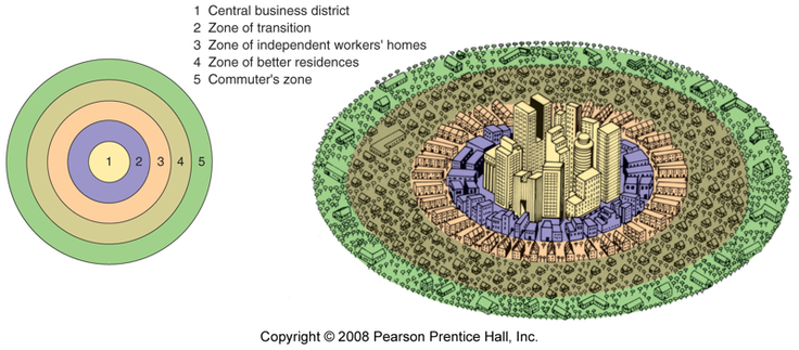
Burgess concluded that city land-use could be identified as a series of concentric rings around the CBD. The CBD will contain all the major shops and offices and be a centre of entertainment. Surrounding this CBD will be the oldest housing, which is in a state of deterioration. Industry will also feature in this area. This is the area often referred to as the inner city or 'zone of transition'. Then, we get three rings of housing. The first will be high density, poor quality that traditionally houses the workers for the factories. Next, is slightly lower density, middle class housing. These will be semi-detached with gardens. Finally, there is a ring of high class housing for those who can afford to commute.
Picture

​Complete the Burgess land use worksheet by using the YouTube below and discussing the zones in class.

Burgess land use worksheet
File Size: 93 kb
File Type: docx
Download File

Central Business District
File Size: 5134 kb
File Type: ppt
Download File


Central Business District (CBD) from Steven Heath

Picture
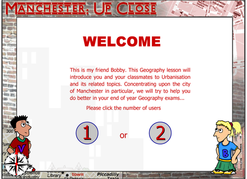
Explore Manchester. Click on the image to the right to play the game.
Picture


Hoyt Urban Model

Picture
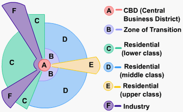
 Hoyt suggested that the city grew in a series of sectors or 'wedges'. These would grow along traditional communication routes. The land-use within a sector would remain the same as like attracts like. For example, a 'high class' sector would remain high class as it would be the most desirable area to live, so only the wealthiest could afford it. An industrial sector would remain industrial as the zone would have a common advantage - perhaps a railway line or river.
Note how the low quality housing is next to the industrial zone, middle class next to low class and high class as far as possible from industry and low class.
Picture
Complete the Hoyt land use worksheet by using the YouTube below and discussing the zones in class

Hoyt Land Use Worksheet
File Size: 92 kb
File Type: docx
Download File


Urban Model for a developing country

Picture
Picture
Picture
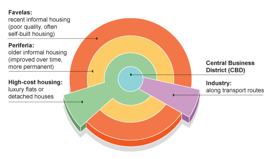
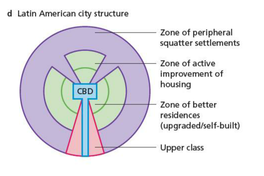
The CBD is similar to that in the developed world and is an area of high-rise offices and shops. However, the similarities stop here. The CBD is surrounded by high-class apartments and older middle class housing, which has been built during colonial times.
You should not forget that there is great wealth in the cities of the developing world and that one of the features of the developing world cities is the great contrast in living standards.

In a ring around the high class housing you find well established 'shanty towns'. These will be the oldest shanty towns in the city and are located here so that residents could find work in the CBD or in the homes of the higher-class residents.
These are not like the shanty towns in the outer circle as they have been steadily improved by the residents. Many will have electricity, water supplies, even schools and clinics. The buildings will have been improved so that corrugated iron is replaced with brick and concrete. This could have been via a redevelopment scheme as outlined in the problems and solutions scheme. Many will now be officially recognised settlements.
​
This zone is referred to as 'periferia' or periphery.
Surrounding this (and infilling any gaps) will be the shanty towns that would be resident to the most recent migrants and would typically have the poorest standards of living as outlined in the urban problems section.
In addition, there are sectors of industrial use (as factories locate along main roads especially those that lead directly to a port) and residential as the high classes choose to leave the polluted and over-crowded inner city.

Follow the following link and discuss which model you think this matches and why
Picture
Urban area 1
Urban Area 2
Urban Area 3

Picture

​Complete the City zone worksheet

Describe the city zones (worksheet)
File Size: 164 kb
File Type: docx
Download File

Urban Environments Revision

Picture
Picture
Print out:
​Discuss the above model. How would this impact what the city looks like?


Urban Problems

Picture
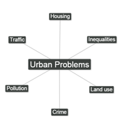
Using Coggle and after watching the YouTube create a spider diagram of the problems that cities can experience. Try to divide them into areas:

Picture
Picture

​
​As a group discuss the possible solutions and add these to your coggle


 London

Picture
Case Study: 
  • Use maps to locate your areas of study. (London Olympic park and Canary Warf)
  • What did these areas used to be?
  • How is London a sprawling Urban area?
  • Why were they selected for redevelopment?
  • How were they redeveloped?
  • What are they like now?
  • What are some of the issues involved 
london.pdf
File Size: 1560 kb
File Type: pdf
Download File


Essay

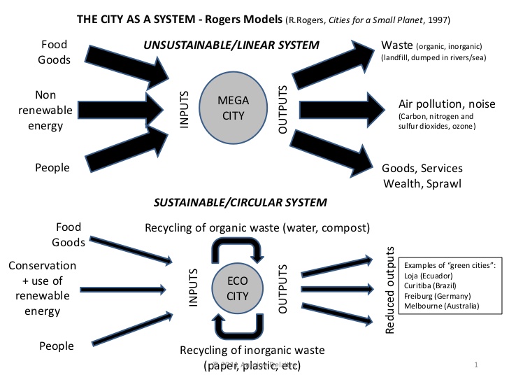
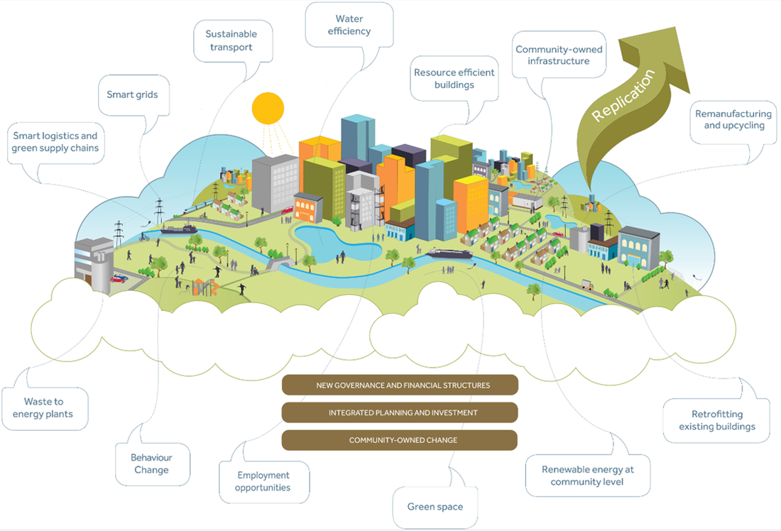
"Can cities be sustainable? Discuss"
Picture
Picture
Picture
10 sustainable cities
Sustainable cities
Sustainability
www.thegeographeronline.net
Picture
The Geographer Online is an educational website aimed at providing geography teaching resources for all levels. 
Created and Developed by: Steven Heath

Follow us!
Creative Commons Licence
This work is licensed under a Creative Commons Attribution-NonCommercial-ShareAlike 4.0 International License.
  • Home
    • How to make a website: Tools and experiences
    • Maps and Regions
    • Travel Photographs and Videos
    • Live: Global Hazards and Disasters
    • Geography in the news
    • The Big Geography Challenge
  • New IB Geography 2017 onwards
    • IB Geography Introduction
    • Part 1: Geographical Themes >
      • Option B: Oceans and coastal margins >
        • 1. Ocean–atmosphere interactions
        • 2. Interactions between oceans and coastal places
        • 3. Managing coastal margins
        • 4. Ocean management futures
      • Option D: Geophysical Hazards >
        • 1. Geophysical systems
        • 2. Geophysical hazard risks
        • 3. Hazard risk and vulnerability
        • 4. Future resilience and adaptation
    • Part 2: Core Units (SL&HL) >
      • Unit 1: Changing Population >
        • 1. Population and economic development patterns
        • 2. Changing Populations and Places
        • 3. Challenges and opportunities
      • Unit 2: Global climate—vulnerability and resilience >
        • 1. Causes of global climate change
        • 2. Consequences of global climate change
        • 3. Responding to global climate change
      • Unit 3: Global resource consumption and security >
        • 1: Global trends in consumption
        • 2: Impacts of changing trends in resource consumption
        • 3: Resource stewardship
    • Part 3: HL Core Extensions >
      • Unit 4: Power, places and networks >
        • 1. Global interactions and global power
      • Unit 5: Human development and diversity
      • Unit 6: Global risks and resilience
    • Internal Assessment
    • Why should I study IB Geography?
  • IB Geography (Old Syllabus)
    • IB Core >
      • 1. Populations in Transition
      • 2. Disparities in Wealth and Development
      • 3. Patterns in Environmental Quality and Sustainability
      • 4. Patterns in Resource Consumption
    • Part 1: Geographical Themes >
      • Oceans and their Coastal Margins
      • Hazards and disasters - risk assessment and response
      • Freshwater - issues and conflicts
      • Urban Environments
    • Global Interactions - HL >
      • Measuring Global Interactions
      • Changing Space - The Shrinking world
      • Economic Interactions and Flows
      • Environmental Change
      • Sociocultural Exchanges
      • Political Outcomes
      • Global Interactions at the Local Level
    • IB Guidance >
      • Syllabus Guidance
      • IB Examination Guidance
    • Extended Essay
  • IGCSE Geography
    • Theme 1: Population and settlement >
      • Population Dynamics
      • Migration
      • Settlements
      • Urban Settlements
      • Urbanisation
    • Theme 2: The natural environment >
      • Plate Tectonics
      • Coasts
      • Rivers
      • Weather and Climate
      • Climate and Ecosystems
    • Theme 3: Economic development >
      • Development
      • Food Production
      • Industry
      • Energy
      • Tourism
      • Water
      • Environmental Risks of Economic development
    • GCSE Key Terms
    • GCSE Coursework
    • Alternative to Coursework
    • IGCSE Geography Examination Advice
    • IGCSE Revision Games
  • Key Stage 3
    • Year 6 >
      • My Place
      • Rivers
      • Brazil
    • Year 7 >
      • Maps and the world
      • Rocky Landscapes
      • Settlement
      • Weather & Climate
    • Year 8 >
      • Maps Introduction
      • Plate Tectonics
      • Economic Activity
      • Biomes
    • Year 9 >
      • Map Skills - review
      • Development
      • Coasts
      • Tourism
      • Paradise lost - Tourism in Thailand
  • AS Level Geography
    • World at Risk
    • Crowded Coasts
  • Geography Skills
  • Donations & Contact
  • YouTube Channel
  • Essential computer programs